Ben Klibreck
| Hill Summit : | Ben Klibreck[NC585299, 962m.] |
| Start : | Vagrastie Bridge. [NC533272 180m ] |
| Summary : | Vagrastie Bridge - Ben Kilbreck - Vagrastie Bridge |
| distance : | 15.0km. |
| ascent : | 900m. |
| time : | 6hr. 10min. |
Ullapool
Current Weather
Last Updated today at : 09:07:53
| Overall : | overcast clouds |
| Temperature : | 12degC. |
| Wind Speed : | 15km/hr. |
| Wind Direction : | ESE |
| Clouds : | overcast clouds |
| Precipitation : | none |
| Sunrise : | 05:55:01 |
| Sunset : | 18:35:25 |
| : | Times are GMT add 1 hour for BST |
Data from openweathermap.org
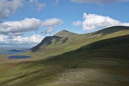
Ben Klibreck is an isolated munro in central Sutherland. Whilst isolated it is only 4k from the nearest reoad and this route goes from here. Ben Klibreck is a long, SW to NE ridge and walking the full length is a much longer walk. There are few paths here, non marked on the map. But the walker can find a way through this land. The route does involve a river crossing so make sure that this route if followed in dry conditions.


