Beinn Mhor
| Start : | Parking on the A865 by Loch Dodhrain. Limited parking (do not obstruct the main road) up the track or alternatively try the minor road just north of the Loch.[NF768345 18m ] |
| Summary : | Loch Dodhrain - beinn Mhor - Loch Dodhrain |
| distance : | 12.0km. |
| ascent : | 700m. |
| time : | 4hr. 50min. |
Stornoway
Current Weather
Last Updated today at : 09:07:54
| Overall : | light rain |
| Temperature : | 13degC. |
| Wind Speed : | 28km/hr. |
| Wind Direction : | ESE |
| Clouds : | scattered clouds |
| Precipitation : | rain 0.27mm. |
| Sunrise : | 05:59:42 |
| Sunset : | 18:40:33 |
| : | Times are GMT add 1 hour for BST |
Data from openweathermap.org
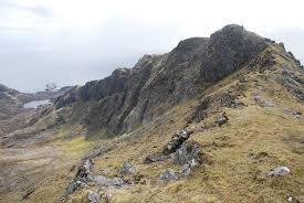
Beinn Mhor is on the Isle of South Uist, and so separate from all the other Fionas in the Outer Hebrides. The approach is to clime the north west ridge which is rocky but not too difficult. To get over to the bottom of the ridge involves walking over some peaklands which can be wet. The return is by the same way as the uphill route.


